Written Directions
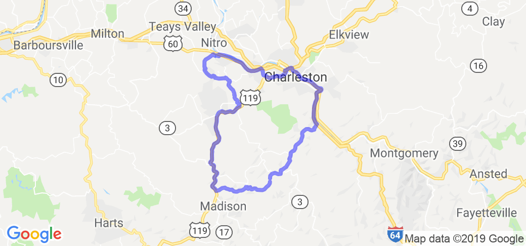
From: Charleston, WV USTo: Saint Albans, WV US
To: Alum Creek, WV US
To: Racine, WV US
To: Charleston, WV US
DRIVING DIRECTIONS
--------------------------------------------------
A) Charleston, WV US
--------------------------------------------------
Merge onto I-64 W/US-119 S via the ramp on the left.
Merge onto US-119 S via EXIT 58A. (go 3.71 miles)
Take the WV-601 ramp toward So. Charleston/Davis Creek Rd.. (go 0.23 miles)
Turn right onto WV-601/Jefferson Rd.
(go 1.23 miles)
Turn left onto WV-601/Jefferson Rd/CR-12/Kanawha Turnpike. (go 0.06 miles)
Turn slight right onto WV-601/Jefferson Rd. (go 0.38 miles)
Take the 1st left onto Maccorkle Ave SW/US-60.
(go 6.45 miles)
--------------------------------------------------
B) Saint Albans, WV US
--------------------------------------------------
Start out going west on Maccorkle Ave/US-60 toward 6th St. (go 2.11 miles)
Turn left onto WV-817/W Main St/Old US-35.
(go 0.02 miles)
Turn left onto W Main St. (go 0.8 miles)
Turn right onto CR-3/Coal River Rd.
(go 4.65 miles)
Turn slight left onto Coal River Rd.
(go 0.79 miles)
Turn left onto Upper Falls Rd.
(go 2.46 miles)
Turn right onto Greenview Rd/CR-9.
(go 3.53 miles)
Turn slight right onto Childress Rd/WV-214.
(go 1.26 miles)
--------------------------------------------------
C) Alum Creek, WV US
--------------------------------------------------
Start out going west on Childress Rd/WV-214 toward Larry Ln. (go 3.34 miles)
Turn left onto Alum Crk. (go 0.35 miles)
Turn right onto US-119 S.
(go 13.58 miles)
Turn left onto WV-3/Rock Creek Rd. Continue to follow WV-3.
(go 13.71 miles)
--------------------------------------------------
D) Racine, WV US
--------------------------------------------------
Turn slight left onto WV-94. (go 9.9 miles)
Merge onto I-77 N/I-64 W via the ramp on the left toward Charleston.
(go 9.45 miles)
--------------------------------------------------
E) Charleston, WV US
--------------------------------------------------
>> TOTAL ESTIMATED TIME: 2 hours 1 minute | DISTANCE: 81.28 miles
Scenery
This route hugs the Coal River in southern WV and then travels over mountains and through coal mining towns.
Drive Enjoyment
Mostly curving and mountainous roads. Some 4 laned roads.
Tourism Opportunities
The Hatfield and McCoy four wheel rider trail crosses this route. Also kayaking on the Coal River is popular.


 Write a review


 | United States")


- Ranch Roads 335, 336,337a | United States")


 | United States")


 | United States")


