Written Directions
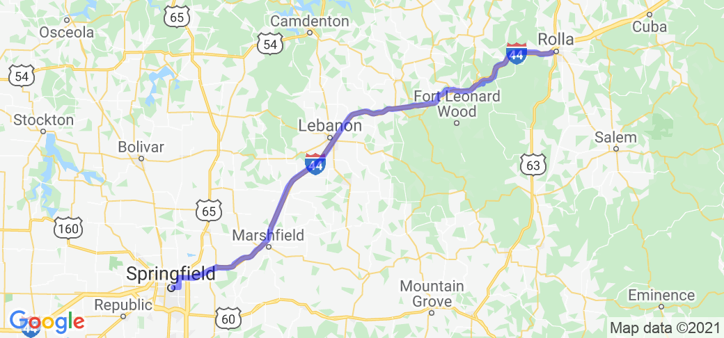
NOTE: Due to technical limitations, the Google Maps route posted on this page does not match these written directions. Use the written directions or the Harley-Davidson Ride Planner route link provided below. Take your best route to the Totem Pole Trading Post, 1413 Martin Springs Dr, in Rolla, MO (near I-44 exit 184). Head west on Martin Springs Dr. for 1.9 miles. Continue on County Rd 7100 for 2.3 miles, the continue onto Eisenhower St/County Rd 7300 for 4.7 miles. Turn left and enter I-44. In 3.7 miles, take exit 172 for MO-D/Jerome. At the intersection, turn left onto MO-D. In 0.1 miles, continue straight onto Powellville Outer Rd, and follow for 3.6 miles. Turn left onto MO-J, then in 0.2 miles, turn right onto MO-Z. In 3 miles, turn left onto Teardrop Rd. In 1.8 miles, turn left onto MO-Z. In 3.9 miles, continue straight onto Old Route 66. in 2.1 miles, continue straight onto Historic 66 E. In 3.6 miles, take the second exit from the roundabout to remain on Hwy 17/Historic 66 W. In 3 miles, turn left to cross over I-44, then turn right to remain on Hwy 17. In 3.5 miles, veer right onto MO-AB. Continue for 12.3 miles, then continue straight onto Route 66 for another 4.8 miles. Turn right onto MO-F, then, in 0,5 miles, turn left onto Route 66. In 5.2 miles, turn right onto Millcreek Rd (I-44 Bus). In 3 miles, turn right to stay on W. Elm St, and continue for 9.5 miles. Turn left onto MO-C, cross over I-44, then, turn right onto MO-CC. Continue for 15.8 miles. Turn left onto E. Hubble Dr. for 2.1 miles, then take the 3rd exit from the roundabout onto W. Hubble Dr. In 0.7 miles, merge onto W. Washington St, then turn right to remain on W. Washington St. In 0.2 miles, turn left to remain on W. Washington St./MO-OO. Continue for 20.9 miles. Turn left onto N. Glenstone Ave. In 2.2 miles, turn right onto E. St Louis Ave. Continue for 1.2 miles. The route ends at the Route 66 Springfield Visitor Center.
Scenery
The views along this route are mixed. Much of the route is essentially the service road for I-44, so the view isn't very interesting, at least on the highway side. However, since the road is often the actual Route 66 road, the side opposite does give an idea of what it was like when Route 66 was in full operation. Where it gets more interesting is when the route veers away from I-44, and goes through the farms and towns of south central Missouri. While there's obviously been a lot of new development since Route 66 was decommissioned, there are still plenty of buildings and sites to give a good idea of what it was like during it's heyday.
Drive Enjoyment
The route has a little bit of everything as far as road conditions. Some sections have been recently repaved, while others are in rougher conditions (the road through Devil's Elbow is in particularly rough shape). In many places, you can tell that you're on the original 1920s-1930s concrete road under either asphalt or chip-and-seal. As befits a major cross country route, the route is not very technically challenging, but is definitely a "cruising" route, with easy curves and rolling hills in the countryside, and going through the "old town" sections of the towns and cities.
Tourism Opportunities
This is Route 66, so the things to see and do along the route are almost too many to list. Your best bet is to find one or more of the many Route 66 resources, including YouTube travel vlogs and Internet travel guides. A good place to start is theroute-66.com, which I used to map the route and describes many of the sites along the route. However, there is a wealth of Route 66 info out there, and many will be tailored to the types of sites and activities that you may be interested in.
Motorcycle Road Additional info
As noted above in the directions, the Google Maps route is not accurate, due to the technical limitations on waypoints. The full, accurate route can be found on the Harley-Davidson Ride Planner, at https://maps.harley-davidson.com/share/rides/4NPqsZf2V
Of particular note are the sections near Arlington/Jerome, and through the "Hooker Cut" and Devil's Elbow. The listed route goes in I-44 and bypasses Arlington and Jerome. The original road exists into Arlington (continue straight instead of getting onto I-44), but the bridge across Little Piney Creek connecting with the original road just south of Jerome was demolished when I-44 was built. There are two notable sights - the remains of the Stoney Dell Resort and Larry Baggett's Trail of Tears Memorial - on the stretch between Jerome and the I-44 exit where you rejoin the road, which can be visited by turning right toward Jerome instead of left.
The listed route turns from the four lane "Hooker Cut" to go through Devil's Elbow. Just before then, as the route goes through Hooker Hollow, the original road weaves across the 1940 four lane road, and there are the remains of some original camps and service stations on the north side, but they are hidden from the road by foliage, and the original 1926 road has not been maintained and is now rough gravel. If you continue straight past the Devil's Elbow turn, you will travel over the 1940 bridge that replaced the more challenging section through Devil's Elbow.


 Write a review


 | United States")


- Ranch Roads 335, 336,337a | United States")


 | United States")


 | United States")


