Written Directions
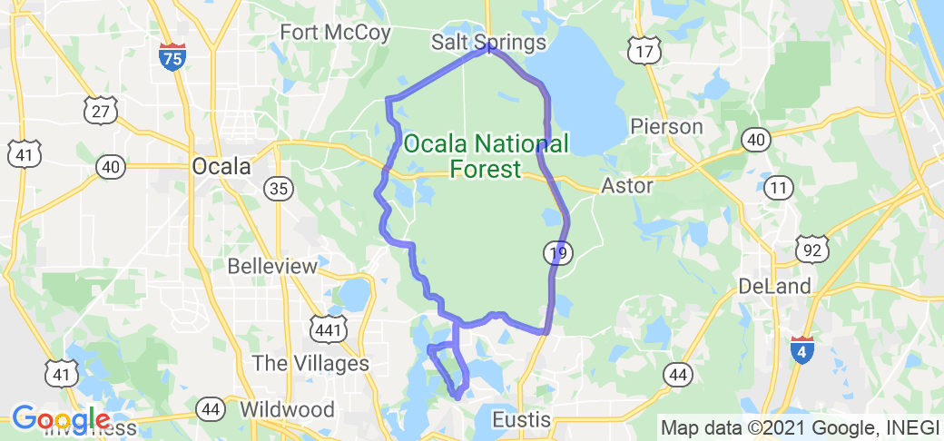
Lisbon, FL Lisbon Church of God 28.88590277549642, -81.77179490653484 GPS. Go west on Emeralda Marsh Road for approximately 8 miles and turn Left on Lake County 452. Go 2.5 miles till road ends at a T junction and take a left on Marion County 42. West on 42 go past Big Bass Lake Camp Ground about 2.5 miles to the Yellow blinking light and take a right on SE 182nd Ave. Rd. go for Approximately 6 miles till the road ends at a T junction at a small gas station in a place called Meadors Corner. There will be a small sign on your right. Take a left and this road becomes Marion County 314A. Take 314A north to it's terminus at Marion County 314 approximately 16 miles. Take a right on Marion 314 and go to Salt Springs, FL. Enter Salt Springs, FL take a right on FL Hwy 19 and go south approximately 33 miles to a small town called Altoona, FL. take a right on Marion county hwy 42 at the only traffic light in Altoona. Take 42 west 8.5 miles back to Lake county 452. Take a left on Lake county 452 and take it approximately 7 miles to a small road on your right called Goose Prairie Road. Just past the Palm Shores Mobile Home Park. Once you take that right Goose Prairie twists and turns back to the Lisbon Church of God. An alternate to that route would be to take a right back onto Emeralda Marsh Road back to the Church back tracking that 8 mile section. I only use the Church as a reference point as Lisbon only has a church and post office. It's pretty small. buy diazepam
Scenery
This loop starts off at the Emeralda Marsh Conservation Area. For absolute best viewing there is a one lane dirt road known as the Florida Birding Trail that goes thru the actual marsh, but that road is only open in the Winter months on Friday, Saturday and Sunday's. During Summer months only the boat ramp is open but worth the short side trip down a well marked dirt road to see the that part of the Marsh. Lots of animal sightings on this section of Emeralda Marsh road. I run this route often and routinely see everything from Gators, to Otters to Bears, and just about any type of bird native to Florida. Better have your GoPro rolling. Beautiful sections of Spanish Moss covered trees. This entire 100 mile route is typical rural Florida country scenery. Trees and small bends in the road most of the way with Hwy 19 being straight as an arrow. Very little traffic control as well. Only a few stop signs one blinking light and maybe 5 stop lights tops the entire 100 mile route. Usually very light traffic weekdays, but on the weekends Hwy 19 can get congested. But this route is best done in the winter when the birding trail is open. It's a five mile dirt road through some really beautiful marsh area. But even if the birding trail is closed, the main road is beautiful by itself.
Drive Enjoyment
Like the rest of Florida the only time the road turns is to go around a lake. Plenty of lakes as this route starts in Lake County. A good mixture of straight and curvy roads. This is really more a scenic route and not really a knee dragging route. The speed limit most of the way is 45 mph and the limit never gets over 55 mph. I've never seen Lake county work it, but Marion County frequently sets up radar on 314A and 314. The section of Marion county 314A north of Marion county hwy 40 is very rough for the first 5 miles. Staying to the right and riding the fog line keeps you out of the really rough stuff. The road is marked: "rough road ahead". When riding into Meadors corner, watch your speed as that junction comes up on you quick.
Tourism Opportunities
If you're looking for amenities, this isn't your route. There are a couple of country stores with fuel spread out along the route and a couple of Dollar General's. The Junction of Marion 314A and Marion County hwy 40 has more to offer in the way of fuel and a few small shops and a Winn-Dixie. Salt Springs has three convenience stores and Altoona has only two. Both at the only traffic light where Hwy 42 crosses. There is a small shop that sells local honey in Altoona. I buy all mine there. It's one block south of the traffic light on the west side of Hwy 19. The really good thing about this route is you're in the dead center of the Ocala National Forest. There are a million other little side trips you can take from this route. There are several Springs and resorts to visit along the way. Alexander Springs is one of the more popular. On the section of Hwy 19 between Salt Springs and Marion hwy 40 on the east side of Hwy 19 is a small rest area called Juniper Wayside. Excellent video op down at the end of the parking lot. Beautiful crystal clear water with plenty of fish in the springs. This is very popular kayaking spot. If you're into riding to a spot then hiking a bit. I highly recommend The birding trail in the Emeralda Marsh. There is a trail head less than three miles from the Lisbon Church of God. You can hike the trail to it's end which is about five miles up and five back. There are also several other hiking trails along this route as well. There is also another trail head about two miles past the boat ramp on the right side of Emeralda Marsh Road. The Ocala National Forest is HUGE. Cell phone service varies. Lots of dead zones no matter which service you have. If you hike in the forest take bear spray!
Motorcycle Road Additional info
https://www.sjrwmd.com/lands/recreation/emeralda-marsh/
https://www.fs.usda.gov/recarea/ocala/recarea/?recid=40244
https://www.fs.usda.gov/recarea/ocala/recreation/recarea/?recid=32362


 Write a review


 | United States")


- Ranch Roads 335, 336,337a | United States")


 | United States")


 | United States")


