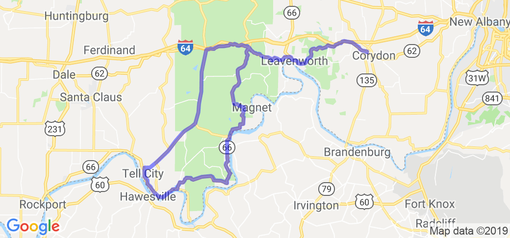
Written Directions
You'll find this route at the southern most part of Indiana, just north of the Ohio River and just north west of Louisville, KY. Begins at the junction of 135 & 62 west of Corydon, IN. Take 62 west through the town of Leavenworth, IN. Take a left onto route 66 at Sulphur Springs, IN. Take 66 as heads south and hugs the Ohio River and then turns north and takes you through Cannelton and on to Tell City. From here you can loop back to Corydon by taking 37 north to St. Croix and then take a right and head east on route 62 all the way back to Corydon, IN. The whole route is about a 115 mile loop.
Scenery
On this tour you'll see Horseshoe Bend, the Hoosier National ForestOhio River by passing through the small Indiana towns. The first section covers Corydon to Leavenworth along Blue River and ends with a breathtaking view of Horseshoe Bend in Leavenworth. Continuing along Hwy 66 at Sulphur Springs to Cannelton- winds through Hoosier National Forest and meets the Ohio River in places (you'll see the Markland Dam on the Ohio).
Drive Enjoyment
62, Corydon to Leavenworth has moderate curves and elevation changes. Freshly re-paved in '03 makes for a smooth ride. 66, Sulphur to Cannelton- The first third has moderate curves, good pavement (just north of Magnet curve). The middle 1/3 has sharp curves and steep elevations changes. Pavement is average. The last 1/3 is smooth with long straights and 90 degree turns.
Tourism Opportunities
"The Dock" under the hill in old Leavenworth (on the river). You can try "The Overlook" restaurant in Leavenworth on Horseshoe bend. A short left from 66 leads to a small "old time" bar and grill in Magnet, IN which sits on the Ohio River (about 1 mile from 66). Derby has a small bar and grill also on 66. Also, if you've never seen a dam work, stop at Markland Dam.
Motorcycle Road Additional info
- View the weather forecast for this area from Yahoo weather .


 Write a review