Written Directions
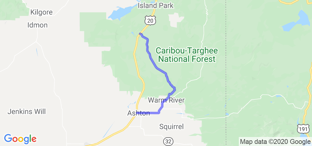
The Mesa Falls Scenic Byway is Idaho State Highway 47. It starts in Ashton, ID, and ends at its junction with Idaho State Highway 20 near Harriman State Park, south of Island Park, ID.
Scenery
South to North route: This lightly traveled route takes you past a couple of small Idaho farming communities, then through extensive agricultural fields. On a clear day (and there are many of these here) you will see impressive views of the west slope of the Grant Teton mountain range. Before long you will descend into the canyon of the Henry 's Fork of the Snake River and on into the Warm River canyon. Almost immediately you climb out of the river canyon on a two-lane road that winds through the Targhee National Forest. There are multiple pull-outs on the east side of the road that offer breathtaking views of the river canyon and surrounding mountains. Before long you will see signs for Lower and then Upper Mesa Falls. Most of the rest of the ride is flat and meandering through the floor of the Island Park caldera, eventually leaving forest behind as you approach the intersection at Hwy 20.
DETAILED SCENERY DESCRIPTION:
NOTE: This route is not open during the winter months - check for access before you go.
1) The first part of this ride winds across the floor of the Island Park super-volcano crater through ponderosa pines of the Caribou-Targhee National Forest.
2) Keep your eye on the horizon to the south as you ride on. On a clear day you will see absolutely breathtaking views of the main peaks of the Grand Tetons.
3) About 17 miles into the ride you will leave the floor of the Island Park caldera and start riding along a ridge between the Snake River canyon to the west and the Warm River Canyon to the east. There are multiple pull-outs on the east side of the road, and you can see the Warm River far below you from some of these.
4) You will gradually descend in elevation toward the Warm River over the next few miles and you will be able to see the Warm River Campground to your left as you come out of the trees toward the floor of the river valley.
5) You will cross a bridge over the Warm River and there is a pullout to the right immediately after that bridge. This is a fish observation area. Fishing is not allowed here, and there are often many HUGE trout in there. If you have some bread, crackers, marshmallows, toss them out there, and if the fish are there, they will let you know!
6) In the last 9 miles of the byway, you will climb out of the river valley onto gently rolling hills of potato fields. Look to your left (east) as you ride and you will be treated to absolutely fantastic views of the Tetons.
Drive Enjoyment
This is a lightly traveled two-lane road. It is not maintained (plowed) during the winter, and in the Spring there are often small to medium sized pot-holes to be aware of. The road includes long straight-aways followed by twisting mountain roads, gentle sweeping curves and more straight-aways.
The upper end of the ride is largely a series of straight segments with gentle curves between them. South of the Upper and Lower Mesa Falls, there is a series of easily managed twisties as you descend toward the Warm River Canyon.
Watch for cattle as you ride through the upper part of the route, since you will ride through some unfenced, open-grazing zones. Watch for cattle guards.
There are a few potholes here and there, but the speed limit of 45 should give you time to spot and avoid these.
Tourism Opportunities
Things to see/do along this route include (IMHO) the best bacon cheeseburger and fries in the region at El Rincon Restaurant or great ice cream at Dave's Jubilee (grocery store deli), both in Ashton, ID. Must see-stops include a fish observation site just before you reach the bridge over the Warm River (toss crackers, etc., and watch 20-30" trout come up for them). The Warm River offers a much-overlooked fishing opportunity as well. Don't miss the Lower and Upper Mesa Falls State Park facilities (small parking fee). For scenery, this ride is hard to beat!
MORE DETAILED GUIDE:
1) About 14.5 miles into the (north-south) ride, you will see signs for Upper Mesa Falls. This is a must-see stop, and features a 114' waterfall as impressive as most of the sights you can see in Yellowstone NP. This site is run by the US Forest Service, and there is a modest parking fee ($5). There is a visitor's center, rangers can answer questions, and there is a nice walkway/stairway that takes you to overlooks of the 114' waterfall on the Henry's Fork of the Snake River. Restrooms and water are available here.
2) Two miles farther down the road the byway you will see signs for Lower Mesa Falls. These falls are not at tall, but, IMO, they are every bit as beautiful. There is no parking fee for this stop. Keep an eye out for birds while you are here - osprey and peregrine falcons are common in this area. There are also restrooms here.
3) Four miles farther south along the route, you will see the Warm River
Campground on the banks of the Warm River to your left. There is a use-fee to stay in this campground, but if you park outside and walk in, there is no charge. There are also restrooms and water available here. This river is stocked every year with rainbow trout, so the fishing is usually pretty good. There are also brown and brook trout if you go farther upstream.
4) The route ends as you roll into the small farming town of Ashton, ID. If you are hungry, my top recommendation is the El Rincon Restaurant (located on the south side of Main St.). They have excellent, authentic Mexican food, plus they make a mean bacon cheeseburger (the best in the region, IMO).
5) If all you want is an ice cream cone, then go all the way through Ashton, get back on Hwy 20 south and take an immediate right to Dave's Jubilee. They always have several options of hard ice cream, and the portions are quite generous.
















 Write a review
