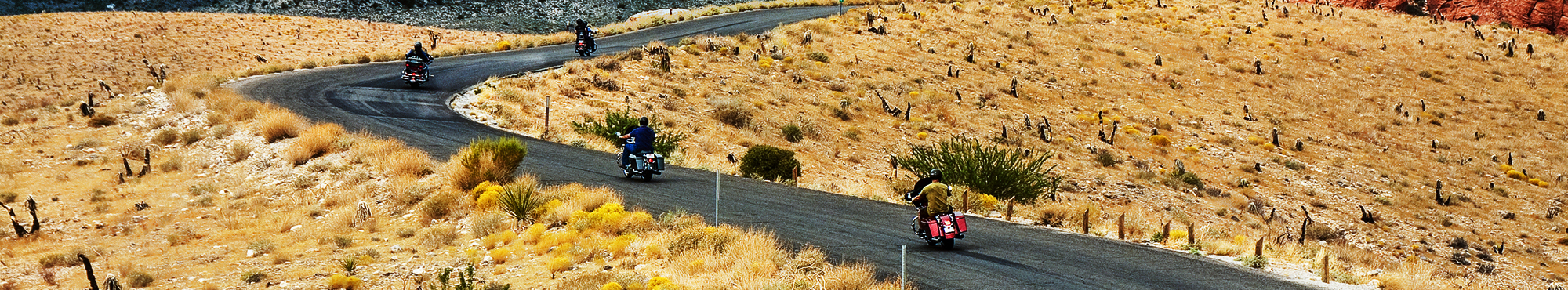
Motorcycle Roads in Texas
"The Lone Star state offers motorcycle riders the best road trips and an exceptional array of scenic diversity with it's over 260,000 square miles of territory, altitudes ranging from sea level to 8,749 feet, and an incredible 624 miles of Gulf of Mexico shoreline. The panhandle region of north Texas (TX) features big rolling grassy plains. The Texas Hill Country found in the center southwest portion of the state offers rolling hills with breathtaking displays of wildflowers in spring. The area also enjoys a year-round lush green landscape with refreshing lakes and rivers making this area a clear favorite of motorcycle riders seeking scenic splendor. Moving further east (east-central and eastern TX) brings motorcycle riders to a vast area noted for its parries, lakes, and piney forest while becoming more green and moist as you approach the Louisiana border. Moving further south will bring you to the Texas Gulf coast region ... 624 miles of coast for you to explore and enjoy. Moving to the southwest corner of Texas will provide motorcycle rides with a scenic backdrop right out of an old western ... landscapes of arid and rugged mountains, blowing tumbleweed, valleys and sandy plains. With all of these choices, Motorcycle riders are sure to find countless miles of memorable motorcycle roads making it the best road trip in the Lone Star State!
"
Best Rated Motorcycle Roads & Rides
Please be patient. Routes will begin to appear on map approximately 10 seconds after the map loads at a rate of one route per second.
Color Key: top-5 ranked routes in the state
#1#2#3#4#5
Routes ranked below the top-5 are drawn in gray
![Waco to Stephenville Scenic Loop | United States Waco to Stephenville Scenic Loop | United States](http://mcr-live.s3.us-west-1.amazonaws.com/route_map_original_images_drupal/map_big_image1630.png)
Scenery
Ride Enjoyment
Tourism Opportunities
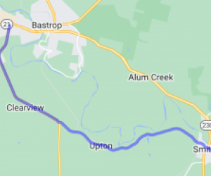
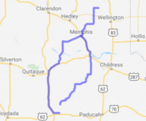
This route covers the Northern Hill Country of Texas, taking some lesser traveled roads with great scenic opportunities, and a variety of road types. From smaller highways to Farm to Market roads,…
![speedo-meter](http://motorcycleroads.com//themes/custom/motorcycleroads/images/speedo-meter.png)
![speedo-arrow](http://motorcycleroads.com//themes/custom/motorcycleroads/images/speedo-arrow.png)
![speedo-meter-grey](http://motorcycleroads.com//themes/custom/motorcycleroads/images/rate-meter-grey.png)
![FM 3090 | United States FM 3090 | United States](http://mcr-live.s3.us-west-1.amazonaws.com/route_map_original_images_drupal/map_big_image1995.png)
Scenery
Ride Enjoyment
Tourism Opportunities
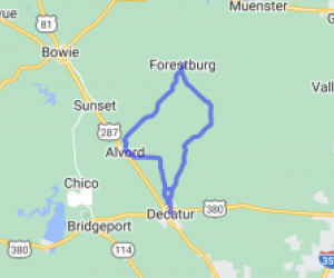
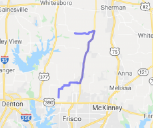
This route cuts through some nice Texas farm country that is scenic but not especially breathtaking.
![speedo-meter](http://motorcycleroads.com//themes/custom/motorcycleroads/images/speedo-meter.png)
![speedo-arrow](http://motorcycleroads.com//themes/custom/motorcycleroads/images/speedo-arrow.png)
![speedo-meter-grey](http://motorcycleroads.com//themes/custom/motorcycleroads/images/rate-meter-grey.png)
![Santo Hwy. | United States Santo Hwy. | United States](http://mcr-live.s3.us-west-1.amazonaws.com/route_map_original_images_drupal/map_big_image573.png)
Scenery
Ride Enjoyment
Tourism Opportunities
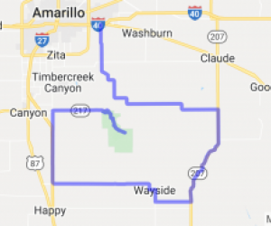
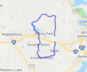
Sort of short but worth the gas. Excellent scenery set in rolling hills with tree lined 15 mile stretch of "real purty" starting in the town of Palo Pinto. The best scenery ends at junction of…
![speedo-meter](http://motorcycleroads.com//themes/custom/motorcycleroads/images/speedo-meter.png)
![speedo-arrow](http://motorcycleroads.com//themes/custom/motorcycleroads/images/speedo-arrow.png)
![speedo-meter-grey](http://motorcycleroads.com//themes/custom/motorcycleroads/images/rate-meter-grey.png)
![FM 1002 and 852 South of Winnsboro | United States FM 1002 and 852 South of Winnsboro | United States](http://mcr-live.s3.us-west-1.amazonaws.com/route_map_original_images_drupal/map_big_image1470.png)
Scenery
Ride Enjoyment
Tourism Opportunities
The first several miles on 1002 has a lot of 20-30 mph curves. As it progresses further north it straightens out, but has a lot of pretty farm land.
North of Hwy 2088 there it again becomes…
![speedo-meter](http://motorcycleroads.com//themes/custom/motorcycleroads/images/speedo-meter.png)
![speedo-arrow](http://motorcycleroads.com//themes/custom/motorcycleroads/images/speedo-arrow.png)
![speedo-meter-grey](http://motorcycleroads.com//themes/custom/motorcycleroads/images/rate-meter-grey.png)
![Del Rio Secluded Desert Loop | United States Del Rio Secluded Desert Loop | United States](http://mcr-live.s3.us-west-1.amazonaws.com/route_map_original_images_drupal/map_big_image1902.png)
Scenery
Ride Enjoyment
Tourism Opportunities
The scenery isn't bad but its not the rolling hills and spectacular views you will find if up in Hill Country. Mostly open, flat, desert views but still better than highway riding.
![speedo-meter](http://motorcycleroads.com//themes/custom/motorcycleroads/images/speedo-meter.png)
![speedo-arrow](http://motorcycleroads.com//themes/custom/motorcycleroads/images/speedo-arrow.png)
![speedo-meter-grey](http://motorcycleroads.com//themes/custom/motorcycleroads/images/rate-meter-grey.png)
![Lower Crabapple to Enchanted Rock | United States Lower Crabapple to Enchanted Rock | United States](http://mcr-live.s3.us-west-1.amazonaws.com/route_map_original_images_drupal/map_big_image548.png)
Scenery
Ride Enjoyment
Tourism Opportunities
Hills, wild animals, creeks, and windy roads are some of the great features of this road. At the end you'll see "Enchanted Rock" which is an amazing site. From the Texas Parks and Wildlife website:…
![speedo-meter](http://motorcycleroads.com//themes/custom/motorcycleroads/images/speedo-meter.png)
![speedo-arrow](http://motorcycleroads.com//themes/custom/motorcycleroads/images/speedo-arrow.png)
![speedo-meter-grey](http://motorcycleroads.com//themes/custom/motorcycleroads/images/rate-meter-grey.png)
![San Angelo Local Loop | United States San Angelo Local Loop | United States](http://mcr-live.s3.us-west-1.amazonaws.com/route_map_original_images_drupal/map_image36563.png)
Scenery
Ride Enjoyment
Tourism Opportunities
The bulk of this ride is on two lane country roads. If you ride RM 853 in the springtime when the wild flowers are out you will wish you had your camera with you to stop and get some photos of the…
![speedo-meter](http://motorcycleroads.com//themes/custom/motorcycleroads/images/speedo-meter.png)
![speedo-arrow](http://motorcycleroads.com//themes/custom/motorcycleroads/images/speedo-arrow.png)
![speedo-meter-grey](http://motorcycleroads.com//themes/custom/motorcycleroads/images/rate-meter-grey.png)
![Old Brazos River Road | United States Old Brazos River Road | United States](http://mcr-live.s3.us-west-1.amazonaws.com/route_map_original_images_drupal/map_big_image1515.png)
Scenery
Ride Enjoyment
Tourism Opportunities
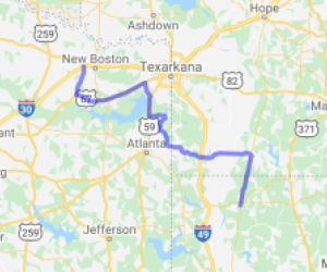
Views of Brazos River, big oak trees with Spanish Moss and miles of Ranchland.
![speedo-meter](http://motorcycleroads.com//themes/custom/motorcycleroads/images/speedo-meter.png)
![speedo-arrow](http://motorcycleroads.com//themes/custom/motorcycleroads/images/speedo-arrow.png)
![speedo-meter-grey](http://motorcycleroads.com//themes/custom/motorcycleroads/images/rate-meter-grey.png)
![FM 279 - an Autumn Gem | United States FM 279 - an Autumn Gem | United States](http://mcr-live.s3.us-west-1.amazonaws.com/route_map_original_images_drupal/map_big_image1292.png)
Scenery
Ride Enjoyment
Tourism Opportunities
On a whim, we left the planned route and took FM 279. The road is hidden under a canopy of trees and has many turns to keep it interesting. We road it during October, we saw the beginning of fall…
![speedo-meter](http://motorcycleroads.com//themes/custom/motorcycleroads/images/speedo-meter.png)
![speedo-arrow](http://motorcycleroads.com//themes/custom/motorcycleroads/images/speedo-arrow.png)
![speedo-meter-grey](http://motorcycleroads.com//themes/custom/motorcycleroads/images/rate-meter-grey.png)
![Curves West of Lake Livingston | United States Curves West of Lake Livingston | United States](http://mcr-live.s3.us-west-1.amazonaws.com/route_map_original_images_drupal/map_big_image2699.png)
Scenery
Ride Enjoyment
Tourism Opportunities
This road is through the tall pine and oak forest of Sam Houston National Park.
![speedo-meter](http://motorcycleroads.com//themes/custom/motorcycleroads/images/speedo-meter.png)
![speedo-arrow](http://motorcycleroads.com//themes/custom/motorcycleroads/images/speedo-arrow.png)
![speedo-meter-grey](http://motorcycleroads.com//themes/custom/motorcycleroads/images/rate-meter-grey.png)
![Channing to Boys Ranch (US 385) | United States Channing to Boys Ranch (US 385) | United States](http://mcr-live.s3.us-west-1.amazonaws.com/route_map_original_images_drupal/map_big_image2314.png)
Scenery
Ride Enjoyment
Tourism Opportunities
You'll see sweeping West Texas Plains, rocky mesas, dry washes, and desert-type plants.
![speedo-meter](http://motorcycleroads.com//themes/custom/motorcycleroads/images/speedo-meter.png)
![speedo-arrow](http://motorcycleroads.com//themes/custom/motorcycleroads/images/speedo-arrow.png)
![speedo-meter-grey](http://motorcycleroads.com//themes/custom/motorcycleroads/images/rate-meter-grey.png)
![Rocksprings to Camp Wood on TX Route 55 | United States Rocksprings to Camp Wood on TX Route 55 | United States](http://mcr-live.s3.us-west-1.amazonaws.com/route_map_original_images_drupal/map_big_image2390.png)
Scenery
Ride Enjoyment
Tourism Opportunities
Beautiful vistas of hills and valleys, along a river at one point. Basically along switchbacks, distance vistas also.
![speedo-meter](http://motorcycleroads.com//themes/custom/motorcycleroads/images/speedo-meter.png)
![speedo-arrow](http://motorcycleroads.com//themes/custom/motorcycleroads/images/speedo-arrow.png)
![speedo-meter-grey](http://motorcycleroads.com//themes/custom/motorcycleroads/images/rate-meter-grey.png)
![Frisco to Lake Ray Hubbard | United States Frisco to Lake Ray Hubbard | United States](http://mcr-live.s3.us-west-1.amazonaws.com/route_map_original_images_drupal/map_big_image1169.png)
Scenery
Ride Enjoyment
Tourism Opportunities
This route has turns and hills along with beautiful homes and landscapes.
![speedo-meter](http://motorcycleroads.com//themes/custom/motorcycleroads/images/speedo-meter.png)
![speedo-arrow](http://motorcycleroads.com//themes/custom/motorcycleroads/images/speedo-arrow.png)
![speedo-meter-grey](http://motorcycleroads.com//themes/custom/motorcycleroads/images/rate-meter-grey.png)
![Comanche Trail | United States Comanche Trail | United States](http://mcr-live.s3.us-west-1.amazonaws.com/route_map_original_images_drupal/map_big_image1754.png)
Scenery
Ride Enjoyment
Tourism Opportunities
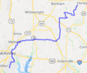
This route cover everything from cultivated fields to raw ranch land with very little traffic. Once you head from Zephyr towards Comanche and beyond, the scenery is fantastic. Nothing but wide open…
![speedo-meter](http://motorcycleroads.com//themes/custom/motorcycleroads/images/speedo-meter.png)
![speedo-arrow](http://motorcycleroads.com//themes/custom/motorcycleroads/images/speedo-arrow.png)
![speedo-meter-grey](http://motorcycleroads.com//themes/custom/motorcycleroads/images/rate-meter-grey.png)
![Highway 697 | United States Highway 697 | United States](http://mcr-live.s3.us-west-1.amazonaws.com/route_map_original_images_drupal/map_big_image574.png)
Scenery
Ride Enjoyment
Tourism Opportunities
road runs along the top of a ridge. Lot's of trees, creek bottoms, very scenic.
![speedo-meter](http://motorcycleroads.com//themes/custom/motorcycleroads/images/speedo-meter.png)
![speedo-arrow](http://motorcycleroads.com//themes/custom/motorcycleroads/images/speedo-arrow.png)
![speedo-meter-grey](http://motorcycleroads.com//themes/custom/motorcycleroads/images/rate-meter-grey.png)
![English 42 | United States English 42 | United States](http://mcr-live.s3.us-west-1.amazonaws.com/route_map_original_images_drupal/map_big_image2077.png)
Scenery
Ride Enjoyment
Tourism Opportunities
I really like how shaded this road is. There are some farm animals and open fields. This isnt the ideal landscape but its different in a great way that I really enjoyed the scene when I rode it.
![speedo-meter](http://motorcycleroads.com//themes/custom/motorcycleroads/images/speedo-meter.png)
![speedo-arrow](http://motorcycleroads.com//themes/custom/motorcycleroads/images/speedo-arrow.png)
![speedo-meter-grey](http://motorcycleroads.com//themes/custom/motorcycleroads/images/rate-meter-grey.png)
![Windom Feed Sack | United States Windom Feed Sack | United States](http://mcr-live.s3.us-west-1.amazonaws.com/route_map_original_images_drupal/map_image62521.png)
Scenery
Ride Enjoyment
Tourism Opportunities
I'm gonna say that the scenery varies depending on the season in which you do this ride. Springtime is always nice when the flowers are in bloom (unless you suffer from allergies). Fall is also a…
![speedo-meter](http://motorcycleroads.com//themes/custom/motorcycleroads/images/speedo-meter.png)
![speedo-arrow](http://motorcycleroads.com//themes/custom/motorcycleroads/images/speedo-arrow.png)
![speedo-meter-grey](http://motorcycleroads.com//themes/custom/motorcycleroads/images/rate-meter-grey.png)
![North Central Texas - Dinosaur Valley Route | United States North Central Texas - Dinosaur Valley Route | United States](http://mcr-live.s3.us-west-1.amazonaws.com/route_map_original_images_drupal/map_big_image2174.png)
Scenery
Ride Enjoyment
Tourism Opportunities
The scenery here is very nice and exceptional for North Central Texas. The rivers are clear and run over visible flat rock bottoms with little water falls. The hills are rugged and, while not…
![speedo-meter](http://motorcycleroads.com//themes/custom/motorcycleroads/images/speedo-meter.png)
![speedo-arrow](http://motorcycleroads.com//themes/custom/motorcycleroads/images/speedo-arrow.png)
![speedo-meter-grey](http://motorcycleroads.com//themes/custom/motorcycleroads/images/rate-meter-grey.png)
![Big Bend Nat'l Park-Ore Road | United States Big Bend Nat'l Park-Ore Road | United States](http://mcr-live.s3.us-west-1.amazonaws.com/route_map_original_images_drupal/map_big_image1037.png)
Scenery
Ride Enjoyment
Tourism Opportunities
Cliffs, forest, skirt the Rio Grande River nearby. Big Bend National Park has national significance as the largest protected area of Chihuahuan Desert topography and ecology in the United States. Few…
![speedo-meter](http://motorcycleroads.com//themes/custom/motorcycleroads/images/speedo-meter.png)
![speedo-arrow](http://motorcycleroads.com//themes/custom/motorcycleroads/images/speedo-arrow.png)
![speedo-meter-grey](http://motorcycleroads.com//themes/custom/motorcycleroads/images/rate-meter-grey.png)
![Palestine to Henderson - The Back Way | United States Palestine to Henderson - The Back Way | United States](http://mcr-live.s3.us-west-1.amazonaws.com/route_map_original_images_drupal/map_big_image566.png)
Scenery
Ride Enjoyment
Tourism Opportunities
Nicely wooded farm country. You'll travel through heavy woods with rolling farmland along the way. This is a nice back area of Texas rarely seen except by locals. If you are looking for a less…
![speedo-meter](http://motorcycleroads.com//themes/custom/motorcycleroads/images/speedo-meter.png)
![speedo-arrow](http://motorcycleroads.com//themes/custom/motorcycleroads/images/speedo-arrow.png)
![speedo-meter-grey](http://motorcycleroads.com//themes/custom/motorcycleroads/images/rate-meter-grey.png)