Motorcycle Roads in Texas
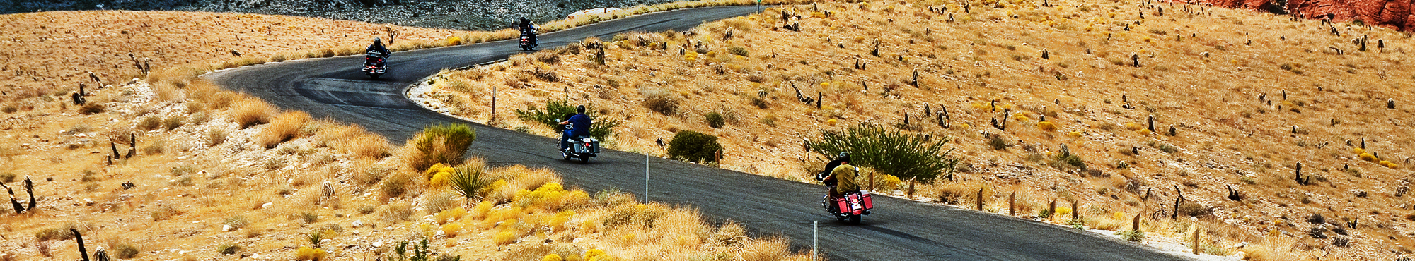
"The Lone Star state offers motorcycle riders the best road trips and an exceptional array of scenic diversity with it's over 260,000 square miles of territory, altitudes ranging from sea level to 8,749 feet, and an incredible 624 miles of Gulf of Mexico shoreline. The panhandle region of north Texas (TX) features big rolling grassy plains. The Texas Hill Country found in the center southwest portion of the state offers rolling hills with breathtaking displays of wildflowers in spring. The area also enjoys a year-round lush green landscape with refreshing lakes and rivers making this area a clear favorite of motorcycle riders seeking scenic splendor. Moving further east (east-central and eastern TX) brings motorcycle riders to a vast area noted for its parries, lakes, and piney forest while becoming more green and moist as you approach the Louisiana border. Moving further south will bring you to the Texas Gulf coast region ... 624 miles of coast for you to explore and enjoy. Moving to the southwest corner of Texas will provide motorcycle rides with a scenic backdrop right out of an old western ... landscapes of arid and rugged mountains, blowing tumbleweed, valleys and sandy plains. With all of these choices, Motorcycle riders are sure to find countless miles of memorable motorcycle roads making it the best road trip in the Lone Star State!
"
Best Rated Motorcycle Roads & Rides
Please be patient. Routes will begin to appear on map approximately 10 seconds after the map loads at a rate of one route per second.
Color Key: top-5 ranked routes in the state
#1#2#3#4#5
Routes ranked below the top-5 are drawn in gray
![Cotton Patch | United States Cotton Patch | United States](http://mcr-live.s3.us-west-1.amazonaws.com/route_map_original_images_drupal/map_big_image953.png)
Scenery
Ride Enjoyment
Tourism Opportunities
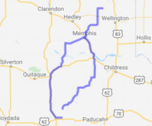
You will see wildlife like coyote, deer, antelope, wild turkey and wild hogs as well as plant life common to this area.
If the cotton is green the area can be kind of pretty. It also is kind of…
![speedo-meter](http://motorcycleroads.com//themes/custom/motorcycleroads/images/speedo-meter.png)
![speedo-arrow](http://motorcycleroads.com//themes/custom/motorcycleroads/images/speedo-arrow.png)
![speedo-meter-grey](http://motorcycleroads.com//themes/custom/motorcycleroads/images/rate-meter-grey.png)
![Green West Texas | United States Green West Texas | United States](http://mcr-live.s3.us-west-1.amazonaws.com/route_map_original_images_drupal/map_big_image2049.png)
Scenery
Ride Enjoyment
Tourism Opportunities
Broad horizon views. Many ranches with ridges and assorted greenery. Big sky.
![speedo-meter](http://motorcycleroads.com//themes/custom/motorcycleroads/images/speedo-meter.png)
![speedo-arrow](http://motorcycleroads.com//themes/custom/motorcycleroads/images/speedo-arrow.png)
![speedo-meter-grey](http://motorcycleroads.com//themes/custom/motorcycleroads/images/rate-meter-grey.png)
![San Angelo State Park Run | United States San Angelo State Park Run | United States](http://mcr-live.s3.us-west-1.amazonaws.com/route_map_original_images_drupal/map_big_image1200.png)
Scenery
Ride Enjoyment
Tourism Opportunities
The route runs along the side of San Angelo State Park so there is plenty of brush and trees along it. If during the dry season then you might have to deal with a good amount of bugs and dust.
![speedo-meter](http://motorcycleroads.com//themes/custom/motorcycleroads/images/speedo-meter.png)
![speedo-arrow](http://motorcycleroads.com//themes/custom/motorcycleroads/images/speedo-arrow.png)
![speedo-meter-grey](http://motorcycleroads.com//themes/custom/motorcycleroads/images/rate-meter-grey.png)
![Logging Trail | United States Logging Trail | United States](http://mcr-live.s3.us-west-1.amazonaws.com/route_map_original_images_drupal/map_big_image553.png)
Scenery
Ride Enjoyment
Tourism Opportunities
The scenery down Hwy. 84 has mostly pine trees from all the managed logging land down both sides of the highway. However, during the fall all the hardwoods are changing colors and it's akin to a…
![speedo-meter](http://motorcycleroads.com//themes/custom/motorcycleroads/images/speedo-meter.png)
![speedo-arrow](http://motorcycleroads.com//themes/custom/motorcycleroads/images/speedo-arrow.png)
![speedo-meter-grey](http://motorcycleroads.com//themes/custom/motorcycleroads/images/rate-meter-grey.png)
![530 Cowboys to Brahmas | United States 530 Cowboys to Brahmas | United States](http://mcr-live.s3.us-west-1.amazonaws.com/route_map_original_images_drupal/map_big_image902.png)
Scenery
Ride Enjoyment
Tourism Opportunities
This route goes through south Texas farm/ranch land everything from Rice to wheat and livestock.
![speedo-meter](http://motorcycleroads.com//themes/custom/motorcycleroads/images/speedo-meter.png)
![speedo-arrow](http://motorcycleroads.com//themes/custom/motorcycleroads/images/speedo-arrow.png)
![speedo-meter-grey](http://motorcycleroads.com//themes/custom/motorcycleroads/images/rate-meter-grey.png)
![The San Antonio Loop Around | United States The San Antonio Loop Around | United States](http://mcr-live.s3.us-west-1.amazonaws.com/route_map_original_images_drupal/map_big_image2655.png)
Scenery
Ride Enjoyment
Tourism Opportunities
From the start you will see hills and high end property with homes. Your typical foliage as you ride but there are some curves and not a lot of traffic. As you get to the second leg of Smithson…
![speedo-meter](http://motorcycleroads.com//themes/custom/motorcycleroads/images/speedo-meter.png)
![speedo-arrow](http://motorcycleroads.com//themes/custom/motorcycleroads/images/speedo-arrow.png)
![speedo-meter-grey](http://motorcycleroads.com//themes/custom/motorcycleroads/images/rate-meter-grey.png)
![East Dallas Bowtie | United States East Dallas Bowtie | United States](http://mcr-live.s3.us-west-1.amazonaws.com/route_map_original_images_drupal/map_big_image903.png)
Scenery
Ride Enjoyment
Tourism Opportunities
If you were looking at the scenery too much then you missed one of the turns. A lot of green, some hills, some water, some of just about everything that is up here.
![speedo-meter](http://motorcycleroads.com//themes/custom/motorcycleroads/images/speedo-meter.png)
![speedo-arrow](http://motorcycleroads.com//themes/custom/motorcycleroads/images/speedo-arrow.png)
![speedo-meter-grey](http://motorcycleroads.com//themes/custom/motorcycleroads/images/rate-meter-grey.png)
![Sam Rayburn Dam | United States Sam Rayburn Dam | United States](http://mcr-live.s3.us-west-1.amazonaws.com/route_map_original_images_drupal/map_big_image1695.png)
Scenery
Ride Enjoyment
Tourism Opportunities
Very great wooded ride. It opens up to a great view at Sam Rayburn Lake. It's definitely worth the trip out.
![speedo-meter](http://motorcycleroads.com//themes/custom/motorcycleroads/images/speedo-meter.png)
![speedo-arrow](http://motorcycleroads.com//themes/custom/motorcycleroads/images/speedo-arrow.png)
![speedo-meter-grey](http://motorcycleroads.com//themes/custom/motorcycleroads/images/rate-meter-grey.png)
![Decatur-Forestburg Loop | United States Decatur-Forestburg Loop | United States](http://mcr-live.s3.us-west-1.amazonaws.com/route_map_original_images_drupal/map_image70658.png)
Scenery
Ride Enjoyment
Tourism Opportunities
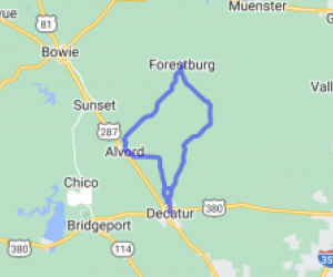
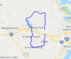
This route essentially circles the LBJ Grasslands. There are hills and valleys--but it's north Texas, not Colorado. Mostly farm and cattle grazing land. For being less than an hour away from the DFW…
![speedo-meter](http://motorcycleroads.com//themes/custom/motorcycleroads/images/speedo-meter.png)
![speedo-arrow](http://motorcycleroads.com//themes/custom/motorcycleroads/images/speedo-arrow.png)
![speedo-meter-grey](http://motorcycleroads.com//themes/custom/motorcycleroads/images/rate-meter-grey.png)
![County Road 134 - Waskom to Jefferson TX | United States County Road 134 - Waskom to Jefferson TX | United States](http://mcr-live.s3.us-west-1.amazonaws.com/route_map_original_images_drupal/map_image36498.png)
Scenery
Ride Enjoyment
Tourism Opportunities
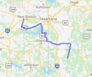
A few Historical markers, and some bayous. Mostly it's a farming/ranching community. This ride starts in Waskom TX. If you are on I-20 take the Caddo Lake exit, HI way 134 North. After leaving…
![speedo-meter](http://motorcycleroads.com//themes/custom/motorcycleroads/images/speedo-meter.png)
![speedo-arrow](http://motorcycleroads.com//themes/custom/motorcycleroads/images/speedo-arrow.png)
![speedo-meter-grey](http://motorcycleroads.com//themes/custom/motorcycleroads/images/rate-meter-grey.png)
![FM 357 - "A Magnum of a Ride" | United States FM 357 - "A Magnum of a Ride" | United States](http://mcr-live.s3.us-west-1.amazonaws.com/route_map_original_images_drupal/map_big_image568.png)
Scenery
Ride Enjoyment
Tourism Opportunities
The ride runs from Kennard to Hwy 59 through Texas Forest Country and Davy Crockett that passes tall timbers, the occasional country church, winding down and around and across streambeds with exposed…
![speedo-meter](http://motorcycleroads.com//themes/custom/motorcycleroads/images/speedo-meter.png)
![speedo-arrow](http://motorcycleroads.com//themes/custom/motorcycleroads/images/speedo-arrow.png)
![speedo-meter-grey](http://motorcycleroads.com//themes/custom/motorcycleroads/images/rate-meter-grey.png)
![Farm to Market 353 - Patroon St | United States Farm to Market 353 - Patroon St | United States](http://mcr-live.s3.us-west-1.amazonaws.com/route_map_original_images_drupal/map_big_image1857.png)
Scenery
Ride Enjoyment
Tourism Opportunities
Farm to Market 353 didn't appear to be much, and my planning of this road was actually a slight detour from where I was previously headed. After about four hours coming from South Houston, it was a…
![speedo-meter](http://motorcycleroads.com//themes/custom/motorcycleroads/images/speedo-meter.png)
![speedo-arrow](http://motorcycleroads.com//themes/custom/motorcycleroads/images/speedo-arrow.png)
![speedo-meter-grey](http://motorcycleroads.com//themes/custom/motorcycleroads/images/rate-meter-grey.png)
![East Texas Beer Run | United States East Texas Beer Run | United States](http://mcr-live.s3.us-west-1.amazonaws.com/route_map_original_images_drupal/map_image57410.png)
Scenery
Ride Enjoyment
Tourism Opportunities
You are going to have stretches over lakes, a lot of rolling forests and farmlands cleared from the temperate rain forest of deep East Texas.
![speedo-meter](http://motorcycleroads.com//themes/custom/motorcycleroads/images/speedo-meter.png)
![speedo-arrow](http://motorcycleroads.com//themes/custom/motorcycleroads/images/speedo-arrow.png)
![speedo-meter-grey](http://motorcycleroads.com//themes/custom/motorcycleroads/images/rate-meter-grey.png)
![FM 1291 and 109 | United States FM 1291 and 109 | United States](http://mcr-live.s3.us-west-1.amazonaws.com/route_map_original_images_drupal/map_big_image2020.png)
Scenery
Ride Enjoyment
Tourism Opportunities
This route has few small hills to see some grass and fields. There really isn't much scenery, at least not when I was there. This road is really fun. I ride from New Ulm toward Fayetteville, turn…
![speedo-meter](http://motorcycleroads.com//themes/custom/motorcycleroads/images/speedo-meter.png)
![speedo-arrow](http://motorcycleroads.com//themes/custom/motorcycleroads/images/speedo-arrow.png)
![speedo-meter-grey](http://motorcycleroads.com//themes/custom/motorcycleroads/images/rate-meter-grey.png)
![FM 2571 to Smithville Coffee House | United States FM 2571 to Smithville Coffee House | United States](http://mcr-live.s3.us-west-1.amazonaws.com/route_map_original_images_drupal/map_image80947.png)
Scenery
Ride Enjoyment
Tourism Opportunities
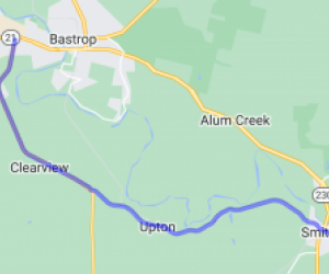
The route crosses Cedar Creek and winds past the Colorado River. Smooth country lanes and gentle curves pass through old growth tunnels of trees and farm plots. Smithville has a cute historic main…
![speedo-meter](http://motorcycleroads.com//themes/custom/motorcycleroads/images/speedo-meter.png)
![speedo-arrow](http://motorcycleroads.com//themes/custom/motorcycleroads/images/speedo-arrow.png)
![speedo-meter-grey](http://motorcycleroads.com//themes/custom/motorcycleroads/images/rate-meter-grey.png)
![Hwy. 87 From Timpson Tx to Galveston | United States Hwy. 87 From Timpson Tx to Galveston | United States](http://mcr-live.s3.us-west-1.amazonaws.com/route_map_original_images_drupal/map_big_image968.png)
Scenery
Ride Enjoyment
Tourism Opportunities
Typical East Texas scenery thru the piney woods. The lower part of the ride near Beaumont is okay but when you get to the Gulf, the view picks right back up.
![speedo-meter](http://motorcycleroads.com//themes/custom/motorcycleroads/images/speedo-meter.png)
![speedo-arrow](http://motorcycleroads.com//themes/custom/motorcycleroads/images/speedo-arrow.png)
![speedo-meter-grey](http://motorcycleroads.com//themes/custom/motorcycleroads/images/rate-meter-grey.png)
![Nice Country Ride from DFW to Pittsburg Hot Links | United States Nice Country Ride from DFW to Pittsburg Hot Links | United States](http://mcr-live.s3.us-west-1.amazonaws.com/route_map_original_images_drupal/map_image59860.png)
Scenery
Ride Enjoyment
Tourism Opportunities
Lots of farmland, many trees, a few lakes, some creeks, plenty of fields, livestock, farms and ranches.
![speedo-meter](http://motorcycleroads.com//themes/custom/motorcycleroads/images/speedo-meter.png)
![speedo-arrow](http://motorcycleroads.com//themes/custom/motorcycleroads/images/speedo-arrow.png)
![speedo-meter-grey](http://motorcycleroads.com//themes/custom/motorcycleroads/images/rate-meter-grey.png)
![Caney creek to Rye | United States Caney creek to Rye | United States](http://mcr-live.s3.us-west-1.amazonaws.com/route_map_original_images_drupal/map_big_image571.png)
Scenery
Ride Enjoyment
Tourism Opportunities
Piney woods galore!!!!!! You will cross the Trinity rivers pretty side and see farm land and old shacks along the way.
![speedo-meter](http://motorcycleroads.com//themes/custom/motorcycleroads/images/speedo-meter.png)
![speedo-arrow](http://motorcycleroads.com//themes/custom/motorcycleroads/images/speedo-arrow.png)
![speedo-meter-grey](http://motorcycleroads.com//themes/custom/motorcycleroads/images/rate-meter-grey.png)
![Pearland to Sandy Point | United States Pearland to Sandy Point | United States](http://mcr-live.s3.us-west-1.amazonaws.com/route_map_original_images_drupal/map_big_image2359.png)
Scenery
Ride Enjoyment
Tourism Opportunities
This route provides gentle curves and bucolic scenery out in the quiet countryside where stress of the city dissipates and drops out of sight behind you. The route starts out in Pearland but quickly…
![speedo-meter](http://motorcycleroads.com//themes/custom/motorcycleroads/images/speedo-meter.png)
![speedo-arrow](http://motorcycleroads.com//themes/custom/motorcycleroads/images/speedo-arrow.png)
![speedo-meter-grey](http://motorcycleroads.com//themes/custom/motorcycleroads/images/rate-meter-grey.png)
![Country Ride North of Dallas | United States Country Ride North of Dallas | United States](http://mcr-live.s3.us-west-1.amazonaws.com/route_map_original_images_drupal/map_image60936.png)
Scenery
Ride Enjoyment
Tourism Opportunities
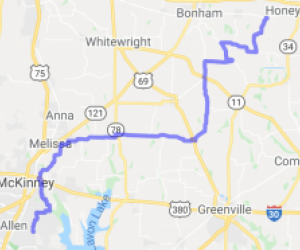
Very rural with mostly two lane roadways. You’ll see a lot of fields, cattle and horses. 902 and some of 455 have some nice curves as well. There are a few Maw and Paw BBQ restaurants along 377,…
![speedo-meter](http://motorcycleroads.com//themes/custom/motorcycleroads/images/speedo-meter.png)
![speedo-arrow](http://motorcycleroads.com//themes/custom/motorcycleroads/images/speedo-arrow.png)
![speedo-meter-grey](http://motorcycleroads.com//themes/custom/motorcycleroads/images/rate-meter-grey.png)