Written Directions
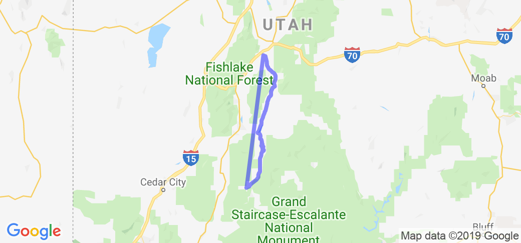
Bryce Canyon City to Richfield, Utah Ride:
When riding Utah in the early spring you must factor in the weather. After spending a wonderful night at the Bryce Canyon Lodge and then riding out to Rainbow Point the next morning, we stopped in Bryce Canyon City to gas up for the next leg of our journey to Torrey, Utah. Before we could pull out the heavens opened up and the already cool temps got cooler. Luckily, the gas station manager let us hang out while we waited for the rain to slacken or stop. We mentioned that we were heading to Torrey. She kinda shook her head and then informed us that it was snowing there. It was drop-back-and-punt time and after some discussion that's what we did. The nearby Best Western had rooms so we took the afternoon off and planned an alternate route for the next day. Our alternate route turned out to be a motorcyclist's gem.
Other Pave Road:
Leaving Bryce Canyon City cross directly over Highway 12 and head north on a two-lane paved road. On the Utah road map this road (John's Valley Road) is designated as "Other Paved Road," meaning it's a local road and not part of the highway system. John's Valley Road follows the East Fork Sevier River up an open range valley. Open range means there are no fences and the cattle roam as they wish. This is not a problem because you can see into the distance and if the cattle are next to or on the road you can see them in plenty of time to slow or stop. The scenery is quietly beautiful - open range. To the left (west) is the Sevier Plateau. To the right (east) are the Table Cliff Plateau and the Escalante Mountains. Every few miles a cattle grate interrupts the road. Signs warn drivers they are approaching a grate. Entrances to local ranches are usually nearby. Other than these entrances there are no other roads intersecting John's Valley Road so the ride is rarely interrupted by traffic.
About 23 miles into the ride you come to the community of Osiris. This is farm country and the homes and outbuildings belie this. The terrain begins to change along here and you'll pass through an ancient lava field now speckled with small trees and vegetation. The road becomes curvy and begins to drop into a small gorge cut by the river. Go slowly through this stretch, enjoy the scenery and be alert for a farm truck. Once you cross the river the road straightens and you come to Antimony, a picturesque small community with a general store and not much else.
A few miles past Antimony is Otter Creek State Park. If you need a break this is the spot - green, cool and inviting. John's Valley Road ends at Route 62 but the ride doesn't. Turn right onto Utah State Route 62 east/north and you will enjoy more off-the-beaten-path riding as you follow Otter Creek north through Angle and Greenwich, Utah. Both are small communities with limited accommodations.
Continuing on you'll come to Burrville. Just past Burrville Route 62 joins Utah State Route 24 and you begin the final leg of the ride. Rt. 24 travels along a plateau at 7,370 feet. Off to your left is Signal Peak (11,223 feet). To your right is Mt. Marvine (11,610 feet). Follow Rt. 24 for 15 miles and take the left fork onto Utah State Road 119 towards Richfield. Coming down off the plateau is a real riding treat. The road offers a bird's-eye view of the farms around Richfield as you descend through the twisties. You may want to watch the pastoral scenery below but keep your eyes on the road. Some of the twisties are sharp and demand a slow approach. It's a fun way to end the ride. Rt. 119 takes you into Richfield, the largest town in Sevier County. It has all of the accommodations you might want or need.
Scenery
This ride through the John's Valley and East Fork Sevier River travels through open range country with mountains to either side. Virtually no traffic except for cattle! A super ride when leaving Bryce Canyon and heading north.
Drive Enjoyment
The Utah road map describes this as "other paved road," meaning it's paved and off-the-beaten-path. The road has no center or shoulder lines but the road surface is well maintained.
Tourism Opportunities
As described earlier this is off-the-beaten-path. There are a few communities along the route but don't plan on gas, food or lodging.
Motorcycle Road Additional info
See a part of Utah passed by most cyclists and motorists. This ride offers quiet beauty as cruise along. You'll be glad you took this road. Best in early morning.


 - Mesa Verde CO to Loma CO | Colorado")


 Write a review


